


Outdoor GPS Shop
Garmin GPSMAP H1i Plus
Garmin GPSMAP H1i Plus
Couldn't load pickup availability
Never knowingly beaten on price – Find out how it works
NEW Garmin GPSMAP H1i Plus - Premium Handheld GPS with inReach® Plus Satellite Technology
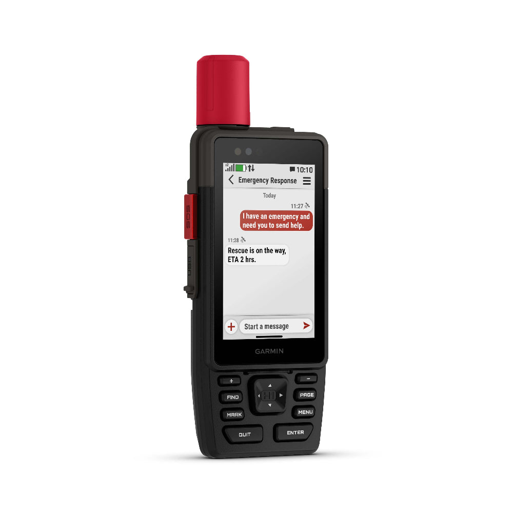
WHEN ADVENTURE CALLS, RESPOND
This rugged handheld GPS has a modern design, preloaded maps and built-in inReach® Plus technology1 to stay in touch beyond mobile network coverage. It’s time to hit the trails.
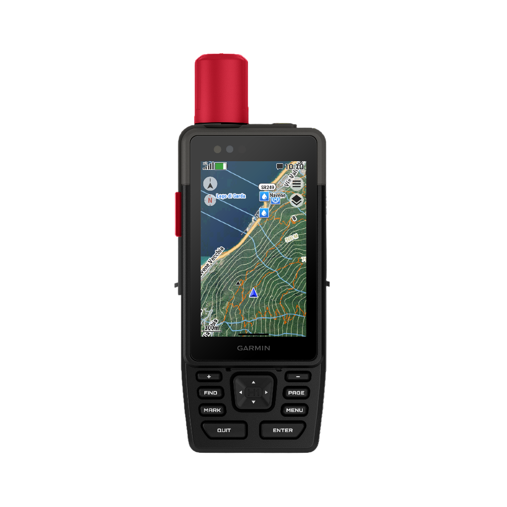
HYBRID DESIGN OFFERS A 3.5″ COLOUR TOUCHSCREEN AND PHYSICAL BUTTONS
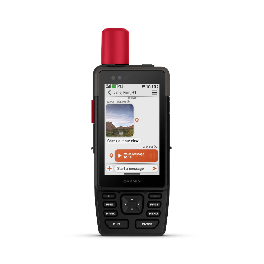
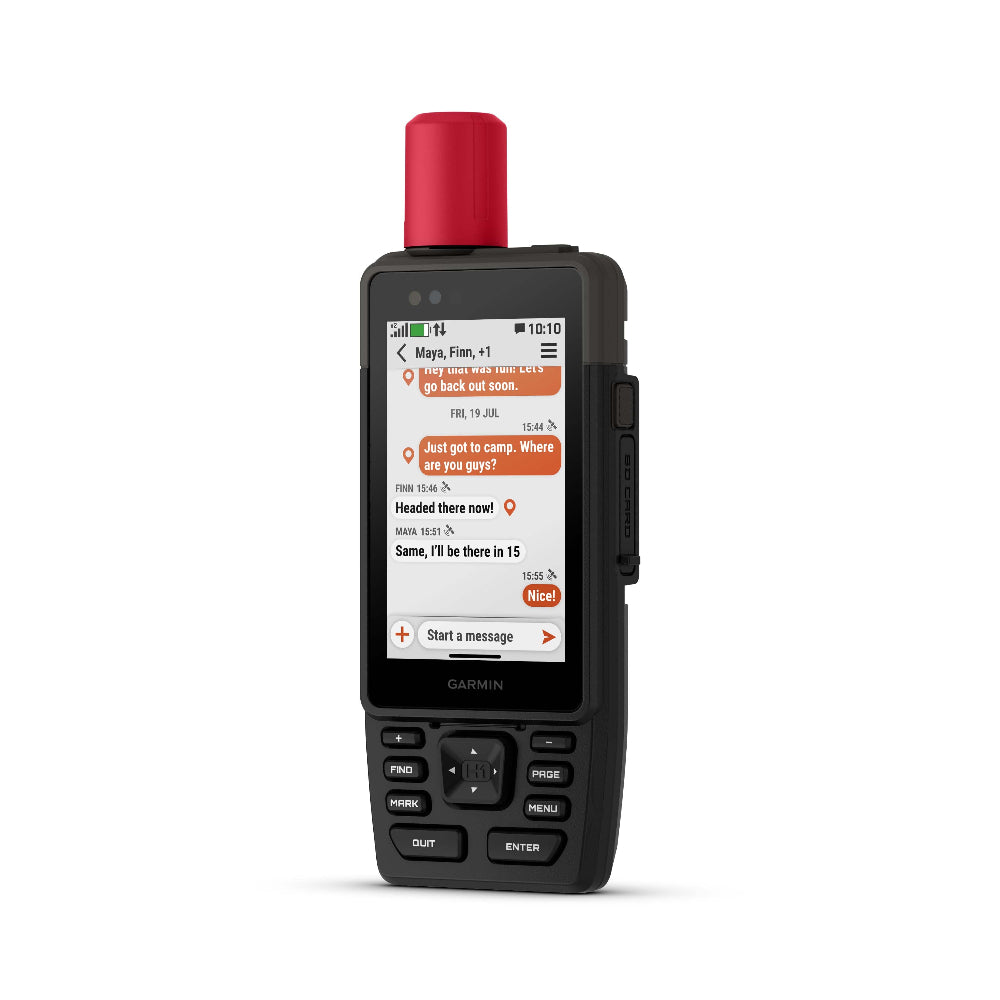
EXCHANGE PHOTOS, VOICE MESSAGES AND TEXT MESSAGES WITH AN INREACH SUBSCRIPTION1
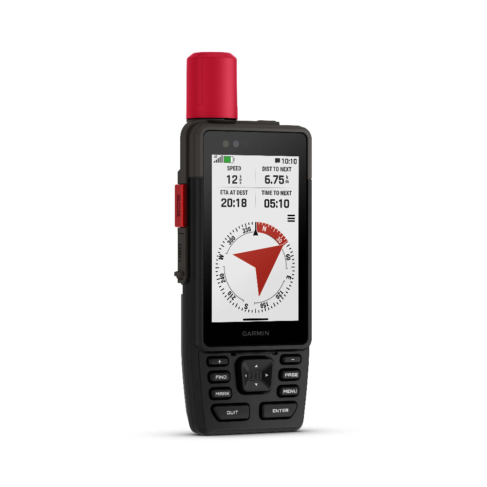
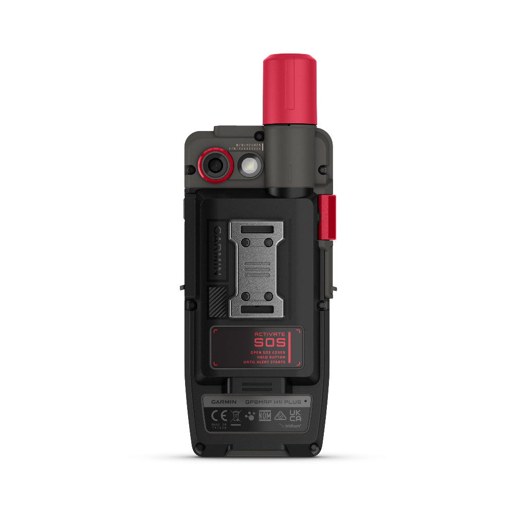
SEND AN SOS MESSAGE TO THE GARMIN RESPONSE℠ CENTRE FOR HELP IN AN EMERGENCY (SUBSCRIPTION REQUIRED)
PRELOADED TOPOACTIVE MAPS, DOWNLOADABLE SATELLITE IMAGERY AND OPTIONAL OUTDOOR MAPS+ CONTENT
LONG BATTERY LIFE OFFERS UP TO 145 HOURS IN GPS MODE
MULTI-BAND GPS AND MULTI-GNSS SUPPORT HELPS PINPOINT YOUR PRECISE LOCATION
We have the following accessories available for your GPSMap H series
Features
WHAT YOU'LL LOVE
Touchscreen Display
The bright, sunlight-readable 3.5″ colour touchscreen has chemically strengthened glass to resist scratches. It is glove-friendly, easy to see and easy to use. Tap, zoom and swipe on the maps to follow your route.
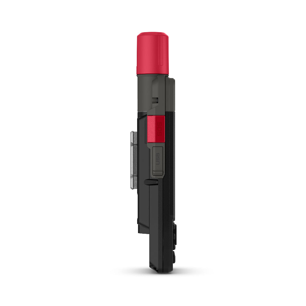
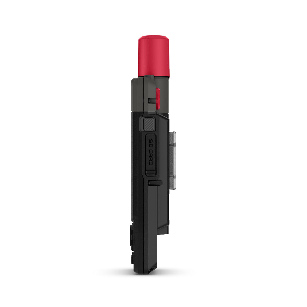
PHYSICAL BUTTONS
The rugged hybrid design also features intuitive push buttons for more versatility when in weather and while wearing gloves. The quick-action button lets users customise functions to their specific needs.
PHOTOS AND VOICE/TEXT MESSAGING
With an active inReach subscription1, send group text messages up to 1,600 characters. You can also exchange photos and voice messages when outside of mobile network coverage.
SOS ALERTS
Trigger an interactive SOS message anytime to the 24/7-staffed Garmin Response international coordination centre for help in an emergency. This requires an active inReach subscription1.
Advanced Navigation
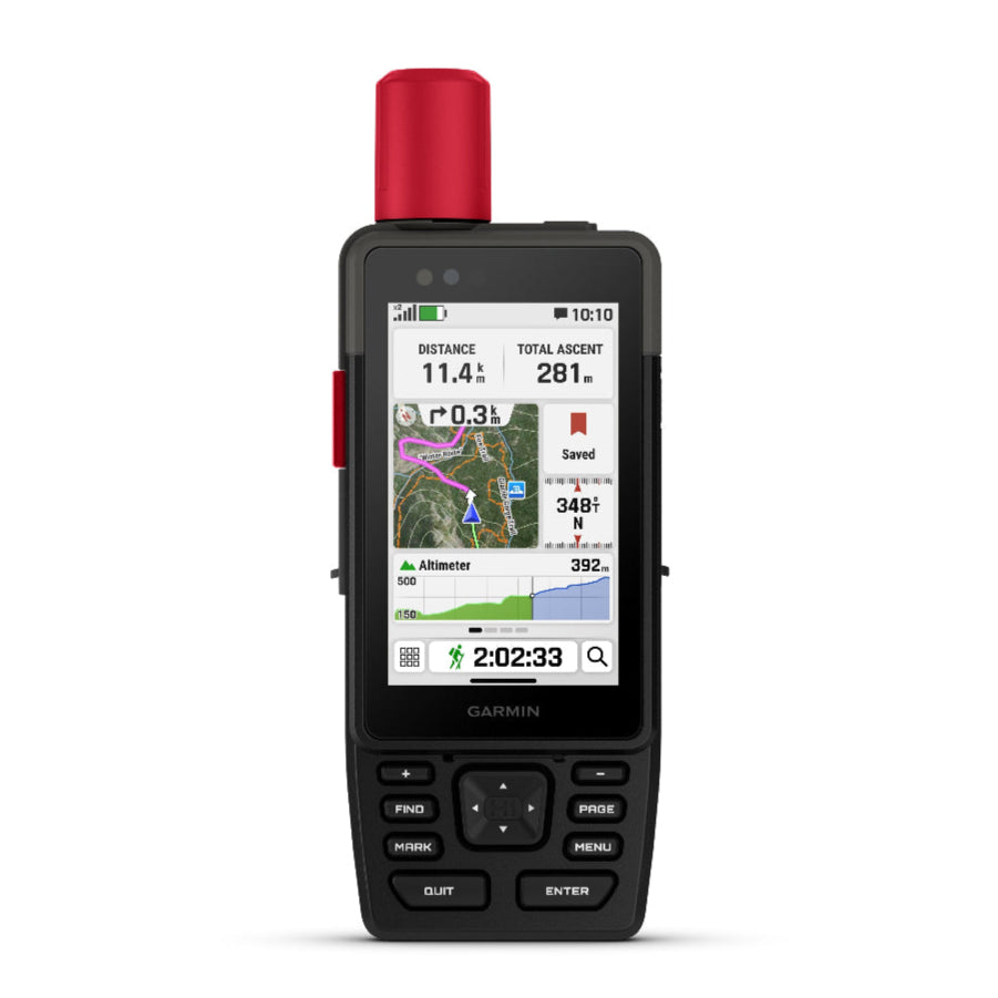
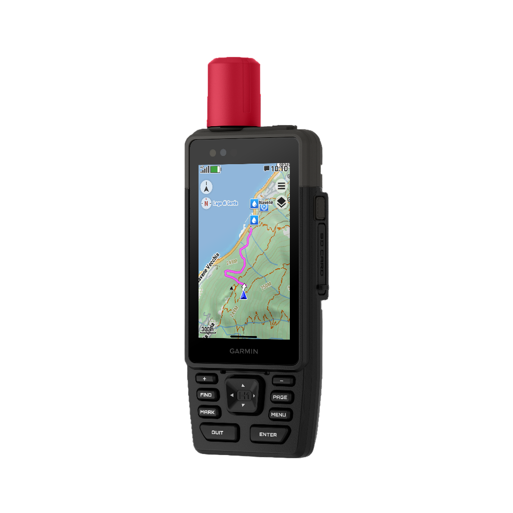
Navigate with preloaded TopoActive maps for the Europe, Middle East and Africa — and easy-to-access global maps. See terrain contours, elevations, geographical points and more.
SATELLITE IMAGERY
Download high-resolution photorealistic maps directly to your device via Wi-Fi® technology. Find trails, pick stand locations and parking, create waypoints and more.
BUILT FOR ADVENTURE
KNOW THE UNKNOWN
OUTDOOR MAPS+
Purchase an Outdoor Maps+ plan for access to a variety of premium mapping content across the globe. Plans are updated regularly and sent to your device over Wi-Fi.
LOCATION ACCURACY
Get multi-band GPS and multi-GNSS support for superior positional accuracy.
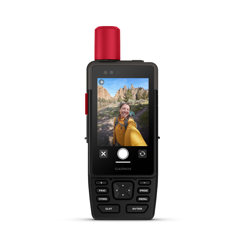
BUILT-IN CAMERAS
The integrated front and back cameras allow you to snap selfies and photos of your trip. With an active inReach subscription1, share your photos in real time even without a mobile network.
VOICE CONTROL
Utilise voice commands to conveniently handle many tasks, including check-ins, start tracking, take a photo and more. Available in Danish, Dutch, English, French, German, Italian, Spanish and Swedish.
LIVETRACK™ SHARING
When you venture off-grid, friends can follow along via satellite technology1 to view your progress, ping your device to see your GPS location and exchange messages. For trips within mobile coverage, loved ones can follow your location in real time and see data such as distance, time and elevation.
GARMIN WEATHER
Get real-time forecast information so you’re aware of the changing conditions. This feature requires an active Wi-Fi connection or an active cellular connection and use of the Garmin Messenger™ app on your paired smartphone. When you travel beyond mobile coverage, access weather updates via satellite1 for your current location, route destination and more.
PLAN YOUR TRIPS
Enjoy seamless trip planning with the ability to easily locate geographic points, share your route and more. This requires an active Wi-Fi connection or cellular connection with use of the Garmin Explore™ app on your compatible smartphone.
EVOLVED DESIGN
HELPFUL TOOLS
Use the built-in bright LED flashlight torch as a beacon or to light your way when the path goes dark. A loud built-in siren can help draw attention if you are in need.
BATTERY LIFE
Long-lasting battery life allows for up to 145 hours in GPS mode.
RUGGED DESIGN
Built to meet MIL-STD 810 for thermal, shock, water (IPX67) and vibration to withstand weather and extreme temperatures.
ON THE GO
This device has an integrated Spine Mount 2 and includes a removable loop with carabiner clip for more versatility on your adventure. It’s also compatible with additional Spine Mount 2 accessories, sold separately.
ABC SENSORS
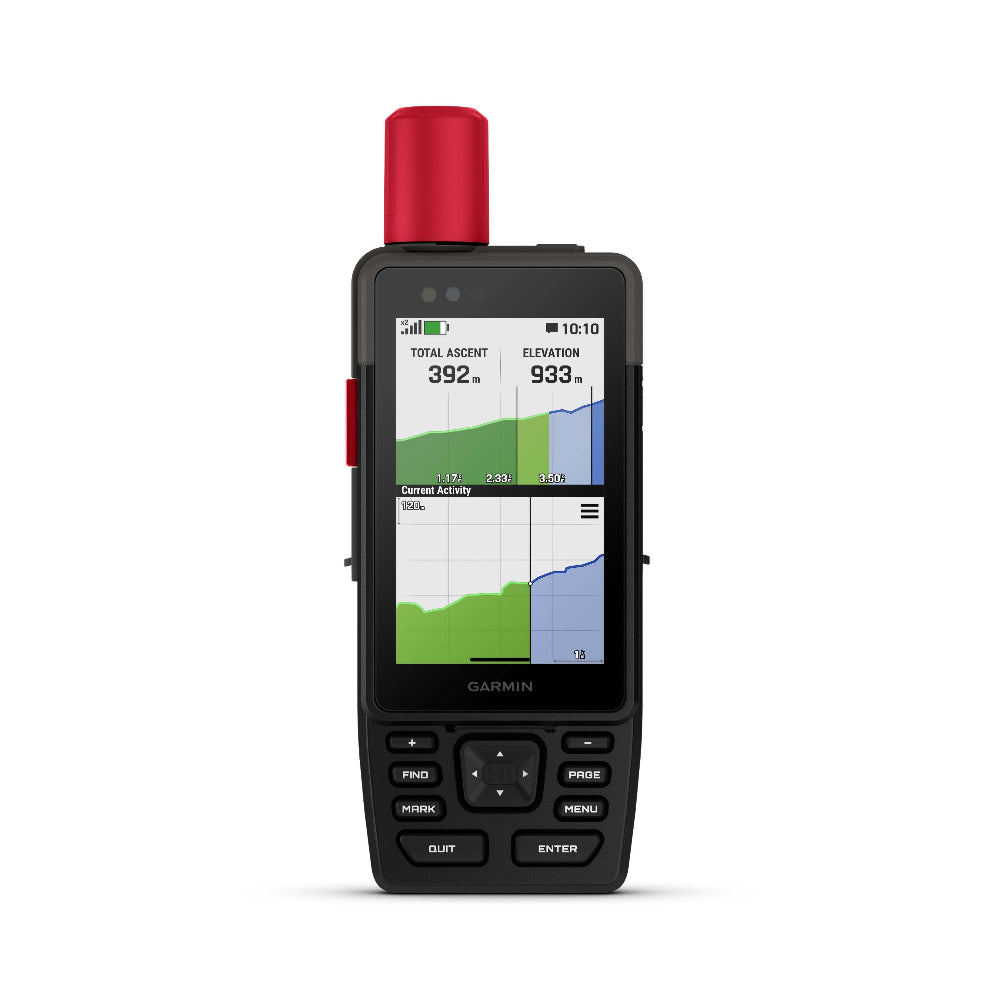
Get a built-in altimeter for elevation data, a barometer to monitor weather and a 3-axis electronic compass to provide direction.
Spec's
General |
|
| Lens material | Chemically strengthened glass |
|---|---|
| Dimension | 6.7 cm x 17.9 cm x 3.3 cm (2.6″ x 7″ x 1.3″) |
| Weight | 290 g (10.2 oz) |
| Water rating | IP67 |
| MIL-STD-810 | Yes (thermal, shock, water); bare unit only |
| Touchscreen | |
| Display Type | Transflective colour TFT |
| Display Size | 4.7 x 7.7 cm (1.9″W x 3″H), 8.9 cm (3.5″ diagonal) |
| Display Resolution | 282 x 470 pixels |
| Battery type | Rechargeable, internal lithium-ion |
| Battery life | Up to 48 hours with inReach enabled, 10 minute tracking, Performance messaging mode Up to 145 hours in GPS Mode Up to 425 hours in Expedition mode with inReach enabled Up to 840 hours in Expedition mode |
| Memory/history | 64 GB (user space varies based on included mapping) |
| Interface | USB-C |
Maps & memory |
|
| Preloaded maps | Yes |
|---|---|
| Ability to add maps | Yes |
| Basemap | Yes |
| Automatic routing (turn by turn routing on roads) for outdoor activities | Yes |
| Map segments | 15,000 |
| Satellite Imagery | Yes (direct to device) |
| Includes detailed hydrographic features (coastlines, lake/river shorelines, wetlands and perennial and seasonal streams) | Yes |
| Includes searchable points of interests (parks, campgrounds, scenic lookouts and picnic sites) | Yes |
| Displays national, state and local parks, forests, and wilderness areas | Yes |
| Storage and Power Capacity | Yes (1 TB max microSD card) |
| Waypoints | Yes |
| Courses | unlimited |
| Activities | 200 |
| Activity profiles | Yes |
| GPX imports | Yes |
| Rinex logging | Yes |
Sensors |
|
| GPS | Yes |
|---|---|
| Galileo | Yes |
| QZSS | Yes |
| BeiDou | Yes |
| IRNSS | Yes |
| Barometric altimeter | Yes |
| Compass | Yes (tilt-compensated 3-axis) |
| High-sensitivity receiver | Yes |
| GPS compass (while moving) | Yes |
| Multi-band frequency | Yes |
Daily smart features |
|
| Connect IQ™ (downloadable watch faces, data fields and apps) | Yes |
|---|---|
| Smart notifications on handheld | Yes |
| Weather (removing Active) | Yes |
| Compatible with Garmin Messenger app | Yes |
| Compatible with Garmin Connect™ Mobile | Yes |
| Voice command | Yes |
| Noise cancellation | Yes |
| Voice assistant | Yes |
| Voice notes | Yes |
| Garmin Share | Yes |
| Passcode | Yes |
| Auto correct keyboard | Yes |
Safety and tracking features |
|
| LiveTrac | Yes |
|---|---|
| Safety siren | Yes |
Tactical features |
|
| Compatible with AB Synapse | Yes |
|---|---|
| Ballistics solver | Yes (unlock required) |
| Dual grid coordinates | Yes |
| Night vision mode | Yes |
Outdoor recreation |
|
| Point-to-point navigation | Yes |
|---|---|
| Spoken turn-by-turn directions | Yes |
| TracBack® | Yes |
| Area calculation | Yes |
| Sun and moon information | Yes |
| Geocaching-friendly | Yes (Geocache Live) |
| Custom maps compatible | Yes (500 custom map tiles) |
| Picture viewer | Yes |
| Camera | Front: 5 MP Rear: 8 MP |
| Flashlight | Yes |
inReach® features |
|
| Interactive SOS | Yes |
|---|---|
| Weather (removing InReach) | Yes |
| Send and receive text messages to SMS and email | Yes |
| Send and receive text messages to other inReach device | Yes |
| Send and receive group messages | Yes |
| Send and receive photos | Yes |
| Send and receive voice messages | Yes |
| Send and receive 1,600 character messages | Yes |
| Exchange locations with other inReach device | Yes |
| MapShare compatible with tracking | Yes |
| Virtual keyboard for custom messaging | Yes |
| Send waypoints to MapShare during trip | Yes |
| Send route selection to MapShare during trip | Yes |
Outdoor applications |
|
| Compatible with Garmin Explore™ app | Yes |
|---|---|
| Garmin Explore website compatible | Yes |
| Smart switching between Wi-Fi, Mobile and Satellite with Garmin Messenger app | Yes |
| Dog tracking | Yes (when paired to compatible dog track system) |
Connections |
|
| Connections Wireless Connectivity | Yes (Wi-Fi®, BLUETOOTH®, ANT+®) |
|---|---|
Security Information |
|
| Security updates until at least (YYYY-MM-DD) | 2027-09-03 |
|---|---|
In the Box
- GPSMAP H1i Plus
- Type A to Type C USB cable
- Loop Carabiner
- Garmin Documentation
FAQ's
1. What are each of the map options available with the Garmin GPSMAP H1i Plus?
This unit has Topoactive mapping on the internal memory and so this option comes as standard with any option you purchase. (Eg, if you purchase TOPO Great Britain Pro 1:50k, you will also get Topoactive mapping on the internal memory)
– Garmin GPSMAP H1i Plus With Western Europe TOPO ACTIVE Mapping
Garmin TOPO ACTIVE mapping is a proper digital map, as you zoom in you get more information and as you zoom out you get less. BUT, it is not an Ordnance Survey map, therefore it does not differentiate between Bridleways and Footpaths, it just marks them as paths.
It covers 47 European countries, compiled using the community-generated OpenStreetMap (OSM) database. Coverage for: Albania, Andorra, Austria, Belarus, Belgium, Bosnia-Herzegovina, Bulgaria, Croatia, Cyprus, Czech Republic, Denmark, Estonia, Finland, France, Germany, Greece, Hungary, Iceland, Ireland, Italy, Kosovo, Latvia, Liechtenstein, Lithuania, Luxembourg, Macedonia, Malta, Moldova, Monaco, Montenegro, Netherlands, Norway, Poland, Portugal, Romania, Russia (Kaliningrad only), San Marino, Serbia, Slovakia, Slovenia, Spain, Sweden, Switzerland, Turkey, Ukraine, United Kingdom and the Vatican City.
– Garmin GPSMAP H1i Plus with TOPO Great Britain Pro 1:50k (2024 v3 edition - most recent)
This is full GB at 1:50k mapping on a map card, which sits in the back of the GPS unit.
The TOPO PRO means that it is the latest map card from Garmin, giving you off road turn by turn routing within the National Parks, this means you can select a location many miles ahead and the GPS will route you via the footpaths to get to that location (like a car sat nav does).
Outside National Parks the GPS will navigate you in a straight line from waypoint to waypoint.
Don’t worry, here at the GPS Training we set the unit up for you so you can easily use these features and we even include a quick start guide so you can quickly get up and running with your GPS unit.
– Garmin GPSMAP H1i Plus with TOPO Great Britain PRO 1:25k, 1:50k and 1:250k Ordnance Survey Map Card - NEW very latest 2024 v3 edition
This is full GB at 1:50k, 1:50k and 1:250k mapping on a map card, which sits in the back of the GPS unit. As you zoom in and out you pass through each of these three map sets.
The TOPO PRO means that it is the latest map card from Garmin, giving you off-road turn by turn routing within the National Parks, this means you can select a location many miles ahead and the GPS will route you via the footpaths to get to that location (like a car sat nav does).
Outside National Parks, the GPS will navigate you in a straight line from waypoint to waypoint.
2. How much are the service plans for Garmin inReach to work on the GPSMAP67i?
You can find these online here.
3. When do I choose and activate my inReach service plan?
You do this online with Garmin as you register and set up your inReach Satellite Communicator.
3. Can you put your Garmin inReach account on hold or stop it for a period?
There are a couple of options to do this –
- inReach Enabled (Pay as you go type service)
This then costs - £7.99 per month and you get –
Unlimited SOS and messaging with Garmin Response
£0.10 per check-in message or reaction
£0.10 per tracking point
£0.50 per text message or weather forecast
- Suspend your plan – If you do this as long as you reactivate your service within 12 months there is no re-actication fee to pay, if you do not recativate within 12 months you then have to pay for the Activation fee again of £39.99.
4. Does the Garmin inReach work using mobile phone signal?
No, and communication (text messages and e-mail) is done using the global Iridium satellite coverage.
5. Does the inReach work in every country?
inReach devices operate on the Iridium satellite network, which provides 100% global coverage. However, some countries require prior permission for the authorized use of a satellite communication device and some countries have banned the use of satellite communications devices. In addition, United States embargoes prohibit providing satellite communications products and services in some countries.
The list below provides our best understanding of countries that may regulate or prohibit the use of a satellite communicator or are on a list of U.S. embargoed countries:
- Taliban controlled Afghanistan
- Crimea region of the Ukraine
- Cuba
- Georgia (SMS)
- India
- Iran
- North Korea
- Myanmar
- Sudan
- Syria
- Thailand
- Vietnam
- China
- Russia
*Regulations and the list above may change without notice. It is important to review the restrictions for satellite communicators for any country you may be travelling to in order to avoid issues for using or carrying an inReach satellite communication device. Your travel destination may have recently changed its laws or policies for various reasons. The US State Department has a list of foreign embassies and consulates that you can contact for more information.
NOTE: SMS messages to Telecom Personal Argentina or Georgia (country) subscribers cannot be delivered as there is currently no route available to this carrier through our international SMS delivery partner. Ghana does not currently have SMS messaging. Currently, there is also an issue with inReach messages being received by SMS phone numbers in Mexico and Romania. For more details, see - inReach Messages Not Received by SMS Phone Numbers in Mexico and inReach Messages Not Received by SMS Phone Numbers in Romania.
6. What accessories do you have available for the GPSMap H series ?
We have the following accessories available for your GPSMap H series
Only from us
Only from us
- GPS Units - Handheld units are set up by one of the Outdoor GPS Shop team to our recommended settings to get the best out of the unit.
- GPS Units - Quick start guide made solely for Outdoor GPS Shop customers
- Garmin GPS Watches - Guide to registering your watch
Delivery
Delivery
Delivery
Any order placed online before 14.30 will be despatched the same working day.
GPS units/ Watches/ Maps
Any products over £100.00 are posted out using Royal Mail Special Delivery which is guaranteed next-day delivery (before 13.00).
Products - £50.00 - £100.00
Any products between £50.00 - £100.00 are sent out Royal Mail 1st class signed for, so should arrive next day.
Products - below £50.00
Products below £50.00 are posted our Royal Mail 2nd Class so should be with you within x 3 working days.